
Using Redoximorphic features to identify the wetland boundaries during Wetland delineation.
The key principle in identifying wetlands during wetland delineation is the presence of water, especially when the water table is at or near the surface or the land is periodically covered with shallow water.
The variations in the extent of saturation of wetlands mean that the presence of the water table (or extent of flooding) will not always be a very reliable parameter for identifying wetlands. Thus the key criteria for classifying wetlands – a high water table and/or periodic inundation – cannot be reliably measured.
In soil that has been saturated for an extended time, roots and micro-organisms gradually consume the oxygen present in pore spaces in the soil. In an unsaturated soil, oxygen consumed in this way would be replenished by diffusion from the air at the soil surface. However, since oxygen diffuses 10 000 times more slowly through water than through air, the process of replenishing depleted soil oxygen in a saturated soil is significantly slower. Thus, once the oxygen in a saturated soil has been depleted, the soil effectively remains anaerobic. Prolonged anaerobic soil conditions result in a change in the chemical characteristics of the mineral elements of the soil, and these manifest visibly through changes in the soil colours. Thus although a high water table or the periodicity of inundation cannot be easily measured directly, it is possible to assess the soil properties for indications of saturation – by examining for the redoxymorphic features which result from prolonged anaerobic conditions.
The two important redoxymorphic features are mottling and gleying (Figure 3); both features caused by prolonged saturated conditions in the soil and the subsequent development of anaerobic conditions.
Gleying is characterised by the development of grey or blueish-grey colours in the mineral soil component. Certain soil components, such as iron and manganese, are insoluble under aerobic conditions. Iron is one of the most abundant elements in soils, and the iron oxide (rust) coatings over soil particles is responsible for the red and brown colours of many soils. However, under prolonged anaerobic conditions iron becomes soluble and can thus be dissolved out of the soil profile. Once most of the iron has been dissolved out of a soil, the soil matrix is left a greyish, greenish or bluish colour, and is said to be gleyed.
Mottling follows the same initial process as gleying, in that the iron becomes soluble and dissolved under anaerobic conditions. A fluctuating water table, common in wetlands that are seasonally or temporarily saturated, results in alternation between aerobic and anaerobic conditions in the soil. Lowering of the water table results in a switch from anaerobic to aerobic soil conditions, causing dissolved iron to return to an insoluble state and be deposited in the form of patches, or mottles, in the soil. Recurrence of this cycle of wetting and drying over many decades concentrates these bright (orange or red) insoluble iron compounds. Thus, soil that is gleyed but has many mottles may be interpreted as indicating a zone that is seasonally or temporarily saturated.
picture
Note
Gleyed soil is characterised by the development of grey or blueish-grey colours in the mineral soil component. Mottling, occurring under conditions of a fluctuating water table, is the development of small patches of concentrated (usually red or orange) iron oxides.
The site is classified as wetland if these indicators are located within 50cm of the original soil surface. (i.e. in the case of developed sites, the predevelopment or pre-infilling level of the soil
Another, albeit invisible, indicator of wetlands soils is odour. Sulphate, which is present in soil, can, like iron, similarly be reduced under the anaerobic conditions associated with saturated soils. The sulphate changes to hydrogen sulphide, a gas which has a rotten egg odour. This odour is often associated with saturated conditions; particularly in soils with high organic matter content as these provide high levels of sulphate
In practice the redoxymorphic features in the soil are used as the primary indicators, since the colours of various soil components are a reliable indicator of wetland soils. An additional benefit of gleying and mottling is that, unlike vegetation, these redoxymorphic indicators can be used on disturbed sites and can be sampled at any time of year (unlike vegetation
In order to standardize wetland assessments (specifically the assessment of gleying and mottling), a Munsell chart 2 should be consulted. If the following grey, dry Munsell colours are present within the top 50cm of the soil, the site qualifies as a wetland soil of either a temporary, seasonal or permanent nature:
- If hue is 2.5Y, then values of 5 or more and chroma values of 2 or less; or values of 6 or more and chroma values of 4 or less.
- If hue is l0YR, then a value of 4 and chroma values of 2 or less; or values of 5 or more and chroma values of 3 or less; or values of 6 or more with a chroma of 4.
- If hue is 7.5YR then values of 5 or more with a chroma of 2 or less; or values of 6 or more with a chroma of 4 or less.
- If hue is 5YR, then a value of 5 and chroma values of 2 or less; or values of 6 or more and chroma values of 4 or less.
- If hue is 5Y, then values of 5 or more and chroma values of 2 or less.
• Using Vegetation
Using Vegetation to identify the wetland edge or boundaries during wetland delineation.
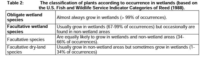
Some plant species can only grow in wetlands and are called obligate wetland plants. These are shown in Table 2. These species can be used as diagnostic indicators of wetlands. Other plant species may preferentially occur within wetlands, but can also rarely be located outside of the legally defined wetland zones. These species are termed facultative species (Table 2), and whilst these are useful indicators in the field, such species are regionally or even locally specific (possibly being within wetlands of one region but outside wetlands in another region) and thus the interpretation of facultative species requires a significant degree of expert knowledge.
Table 2: The classification of plants according to occurrence in wetlands (based on the U.S. Fish and Wildlife Service Indicator Categories of Reed (1988).
Thus, with the exclusion of obligate wetland species (listed in Appendix C), when using vegetation indicators for wetland delineation, more emphasis should be placed on the group of species that dominate the plant community, instead of a specific indicator species.
Thus, the presence of dispersed individual plants of an upland plant species in a community dominated by wetland species is not scattered to conclude that the area is not a wetland.
The existence of obligate wetland species in an area confirms the wetland status of the site, the existence of a few wetland facultative species in a community dominated by upland species is not a sufficient basis for concluding that the area is a wetland. Facultative wetland species are usually found in wetlands, but may also occasionally be found in terrestrial areas.
The main target of wetland delineation is to identify the boundaries of the wetland (outer edge of the temporary zone). More information is needed from site and understanding of the temporary, seasonal and permanent zones of a certain wetland. A wetland delineator may require this information on some project sites.
To an extent, it’s possible to characterize these zones basing on the types of hydrophilic vegetation they support
Table 3: shows a summary of the vegetation indicators which may be expected in the different wetness zones.
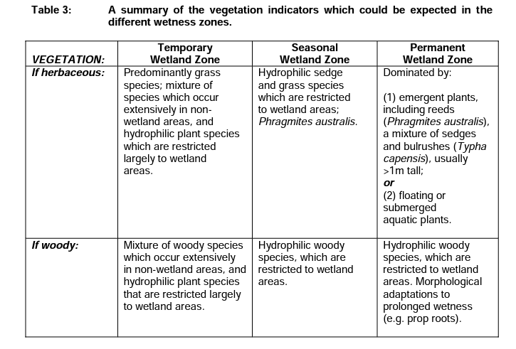
The boundaries of a wetland, that is to say the outer edge of the temporary wetland zone, would be expected to be dominated by facultative wetland vegetation species (Table 3).
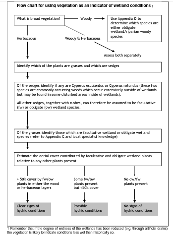
The basic approach to using vegetation to delineate wetland boundaries, or to verify the edges as indicated by redoxymorphic features, is to assess the site according to the presence of obligate wetland species, and the presence and dominance of facultative wetland species Check for the presence of any obligate wetland plants (as listed in Appendix C). In addition, rushes and all sedges (with the notable exception of Cyperus esculentus and Cyperus rotundus, which are commonly occurring weedy sedges that occur extensively on disturbed areas inside and outside of wetlands) can be considered to be at least facultative wetland species (unless indicated as obligates in Appendix C) The site should further be assessed based on the practitioner‟s local expertise to identify any other local or regional facultative wetland species.
To identify wetland areas using vegetation:
1) The presence of wetland obligate plant species can be considered to be diagnostic of wetland conditions (Appendix C provides a provisional list of obligate wetland plants for South Africa, denoted by the province in which they can be expected).
2) For other areas of the site which may not have readily identifiable obligate wetland plants, the zones should be assessed for the dominance of facultative wetland plants.
a) Where more than 50% of the zone is covered by facultative wetland plants in either the wood or herbaceous layers, clear signs of wetland indications can be assumed.
b) Where facultative plants are present, but their cover is less than 50% of the zone, this can be assumed to indicate possible wetland conditions. Confirm with the redoxymorphic features in the soil. c. Where no facultative plants are present, this can be assumed to indicate an absence of wetland conditions. However remember that if the degree of saturation/inundation of the wetlands has been reduced (e.g. through artificial drains or reduced flooding from upstream), then the vegetation is likely to indicate conditions less wet than what historically occurred. Confirm that there are no redoxymorphic features in the soil before confirming the terrestrial status of such sites.
Combining the indicators to delineate the edge of the wetland
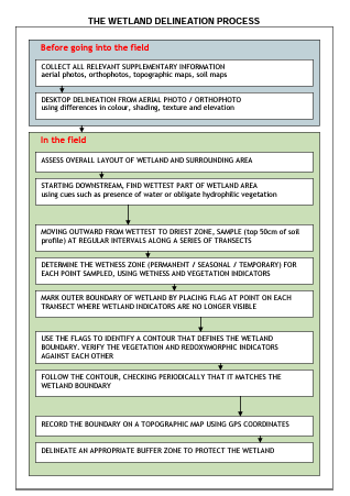
The decision as to whether a particular area qualifies as a wetland is based on the number of wetland indicators it displays. The edges of a wetland are established at the point where these indicators are no longer present. While some wetlands display all of the indicators under undisturbed conditions, the critical question is: “what is the minimum set of indicators that need to be present in order to qualify an area as a wetland?” Sole reliance on any one indicator as the determinant of wetlands can sometimes be misleading. Many plant species can grow successfully both in and out of wetlands, and soil wetness indicators may persist for decades following alteration of the hydrology of a wetland. The presence of multiple indicators provides a logical, defensible, and technical basis for identifying an area as wetland, but an area should display a minimum of either redoxymorphic features or wetland vegetation indicators in order to be classified as a wetland. Verification of the terrain unit and soil form indicators may increase the level of confidence in deciding the boundary, but these indicators are not diagnostic.
Note.
An area should display at least redoxymorphic features or wetland vegetation indicators in order to be classified as a wetland. The redoxymorphic features should be within 50cm of the soil surface. The presence of both vegetation and redoxymorphic indicators increases the confidence and precision of the delineation, but these may not always occur simultaneously at all sites.
Related Posts:


More posts:
 What is wetland delineation?
Steps and procedures taken when conducting wetland delineation
Cómo reparar un refrigerador por ti mismo.
¿Cómo funciona la limpieza en seco?
¿Cómo funciona un cepillo de dientes eléctrico?
Cómo quitar las manchas de Marcadores Permanentes de la Ropa
A Comprehensive Guide to Paper Weights.
How Much Does 20-Pound Bond Paper Weigh?
What is wetland delineation?
Steps and procedures taken when conducting wetland delineation
Cómo reparar un refrigerador por ti mismo.
¿Cómo funciona la limpieza en seco?
¿Cómo funciona un cepillo de dientes eléctrico?
Cómo quitar las manchas de Marcadores Permanentes de la Ropa
A Comprehensive Guide to Paper Weights.
How Much Does 20-Pound Bond Paper Weigh?
I enoy what you guys tend to be up too. Thiss soort oof
cclever work and coverage! Keep up the very good workks guys I’ve yoou
guys to my oown blogroll.